

GPS Asset Tracking for Aerospace & Defense: Active, Precise, Reliable
GPS asset tracking delivers the real-time visibility that defense supply chain managers, logistics coordinators, and warehouse operations teams need to maintain operational readiness while reducing risk and overhead costs.
LocatorX GPS Tech Specs
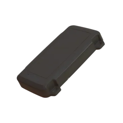
Our GPS sensor is designed with precision and security.
- TAA-Compliant sensors
- Dimensions: 83 mm wide x 131 mm length x 18.5 mm width
- Temperature range: -40 to +80 degrees C
- IP68
- Connectivity: Terrestrial (LET-M Cellular – 700-2200 MHZ bands) + Satellite (NB-IoT NTN Release 17 Compliant
- Accuracy: 4 meters
- Supports OTA (Over the Air) firmware upgrades and locally via USB-C interface
- Battery life: Up to 6 years (varies based on reporting frequency)
- Global coverage
- Weight: 0.15 oz
- Certifications: FCC and UL
Next Gen Dual Mode GPS Sensor: Cellular + Satellite
Our next gen, dual-mode sensor provides maximum coverage by supporting both cellular and satellite connectivity in one unit to ensure your assets are always visible around the globe.
IP68-rated,UV-resistant enclosure is designed to function in the harshest of environments. Can withstand impact, fine dust, submersion, and extreme temperatures for dependable and reliable connectivity, where and when you need it.

Powered by high precision GNSS tracking to ensure superior accuracy down to a few meters. Cell tower fallback for locations where GNSS satellite visibility is limited. Accelerometer based movement tracking.

TAA-Compliant devices providing end-to-end data security. Highly resilient and edge-aware network design, secure and purpose-built for IoT applications.

The data feed from LocatorX can be integrated directly into existing defense platforms.

Leveraging a highly flexible, 5G NTN (Non-Terrestrial Network) 3GPP compliant global satellite network. Access critical data in even the most extreme locations.

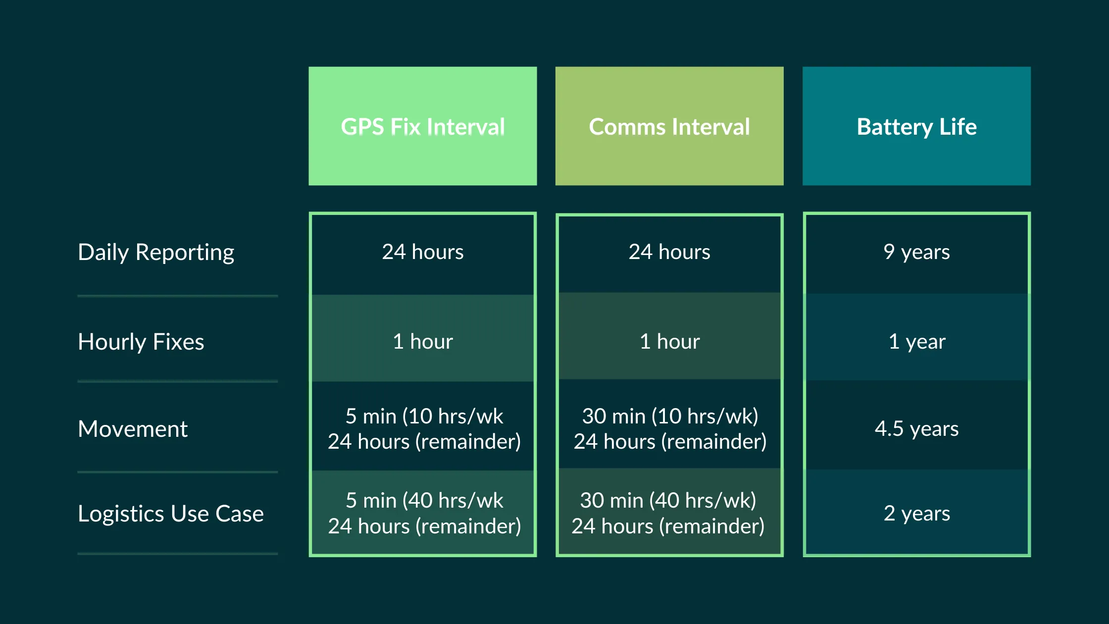
Low deploy and service costs with “Deploy Once” design. Up to 6+ years* deployment life, with the option of user replaceable batteries.

Powered by 2x AA batteries, our GPT sensor can last for 6+ years* depending on the frequency of data reporting including daily, hourly, or movement-based activities.

Estimated Battery Life
When GPS Excels: Optimal Use Cases for Defense Asset Tracking
GPS is best for when your assets move across large geographic areas or operate in environments where other tracking technologies fall short due to signal or accuracy. GPS is the preferred solution for:

Long-Range Asset Movement
When tracking equipment, vehicles, or containers moving between facilities, bases, or operational theaters, GPS provides continuous visibility regardless of distance. Unlike RFID or Bluetooth solutions limited to short ranges, GPS maintains tracking capability across continents.

Outdoor Operations
GPS performs optimally in open environments where satellite signals can reach receivers unobstructed. This makes it ideal for tracking assets in transit or assets located in outdoor storage areas.

High-Value Asset Protection
When tracking critical or expensive equipment where theft prevention and rapid recovery are priorities, GPS provides the real-time alerts and location precision needed for effective security operations.
When Alternative Technologies to GPS May Be Better
For assets located within buildings and warehouse facilities, GPS is not an ideal fit since the GPS signal does not pass through dense materials such as concrete and steel well. It needs a clear path to the cell tower or satellite. BLE would be a better solution for real-time indoor tracking.
Some defense facilities and in-theater locations restrict GPS usage due to security protocols or concerns about signal interception. In these cases, closed-loop tracking systems using other technologies may be required.


GPS is more costly depending on the location coverage required and the ongoing monthly subscription fees. For low-value assets or extremely high volume, this may not be a cost-effective solution.
GPS units tend to be larger in size and depending upon the real estate or use cases, a smaller BLE or LoRaWAN sensor could be a better fit.
GPS receivers consume more power than other active or passive tracking options. For sensors that must operate for extended periods without battery replacement or charging, lower-power alternatives might be more practical.
GPS: Making the Right Tracking Choice for Your Mission
GPS asset tracking offers defense organizations a proven, reliable solution for maintaining visibility of critical assets in transit. The key to successful implementation is understanding your specific requirements and how they align to GPS capabilities. By understanding when GPS excels and when alternative technologies might be more appropriate, defense supply chain managers, logistics coordinators, and warehouse operations teams can make informed decisions that enhance operational efficiency while maintaining the security and reliability standards that defense operations require for mission success.
LEARN MOREWhat to consider when deciding if GPS is right for your use case:
Determine the positioning precision needed for your application. Standard GPS provides 3-5 meter accuracy.

Consider how often you need location updates. Real-time tracking requires more power and cellular data than periodic reporting suitable for non-critical assets.
Balance reporting frequency with battery life requirements. More frequent updates provide better visibility but reduce operational time between battery changes.
Verify the sensor's operating temperature range, shock resistance, and IP rating match your deployment environment.
Evaluate cellular carrier compatibility, roaming capabilities for multi-region operations, and data plan requirements.
Assess encryption capabilities, authentication requirements, and any cybersecurity certifications relevant to defense applications.
Confirm compatibility with existing asset management systems, ERP platforms, or logistics software.
Consider physical mounting requirements, antenna placement, and installation complexity for your specific assets.
Evaluate the ability to create custom geographic boundaries and configure appropriate alert mechanisms.
Assess capabilities for over-the-air (OTA) configuration updates, firmware management, and remote troubleshooting.
Consider how easily the solution can expand as your tracking requirements grow.
Evaluate technical support availability, training resources, and long-term vendor viability for defense sector requirements.
Frequent GPS Questions:
Global Positioning System (GPS) technology leverages a constellation of satellites to provide precise location data anywhere on Earth. GPS works by measuring the time it takes for signals to travel from multiple satellites to a receiver, triangulating position with accuracy typically within3-5 meters under optimal conditions.
No, some GPS devices offer only cellular or satellite support, not combined.
GPS is one of the more expensive tracking technologies due to multiple variables including where the device is manufactured, cellular and/or satellite data fees, monthly services charges, geo coverage.
Sensors that are used in the defense industry are typically designed to endure more rugged conditions, manufactured in the United States or a TAA-Compliant country, and may have specific certifications depending on the use case.
The History of GPS
GPS, owned by US Space Force, was originally developed by the U.S. Department of Defense during the Cold War. There is no single inventor of GPS, rather several key individuals are credited with the development of including Dr. Ivan Getting, Bradford Parkinson, Roger Easton, and Gladys Wells.
Several prior technological advancements dating back to the early 1950s are credited as foundational technologies in GPS evolution. These included Sputnik’s Doppler Effect, ARPA’s Transit global satellite navigation system developed for the Navy’s submarine navigation, and a key study conducted by The Aerospace Corporation in 1963 for the Navy resulting in the 621-B system. The study was the turning point for the technology. Aerospace engineers James Woodford and Hideyoshi Nakamura authored the study that provided recommendations to build an advanced satellite program that provided continuous location tracking of vehicles for the DoD.
In 1973, the DoD began development of GPS, initially called ‘Navstar GPS.’ Although it started in 1973, the first initial satellite did not launch until 1978. It went through years of testing and refinements until it was finally classified as “Full Operational Capability(FOC)” by the military almost two decades later on April 27, 1995.
While not classified as FOC until 1995, tragedy struck in 1983 prompting President Ronald Regan to make the case to leverage GPS outside of the military. On September 1, 1983, Korean Airlines flight 007 was traveling from Anchorage, AL to Seoul, Korea and accidentally flew into restricted Soviet airspace. The Soviets thought the commercial flight was a US spy plane and shot it down in the Sea of Japan. All 269 passengers and crew perished. The incident prompted President Regan to request that airplanes leverage GPS technology to improve navigation capabilities and safety for air travel. However, due to growing concerns by the military that other countries could intercept and leverage the GPS signals, the signal was intentionally degraded for security reasons. This became known as ‘Selective Availability’. The US military used specialized, encrypted receivers to read the GPS signal with accuracy.
In 1988, Magellan Corporation introduced the Magellan NAV 1000, the first commercially available handheld GPS unit that debuted at $3,000. Due to Selective Availability, the units had limitations but provided civilians navigations capabilities not seen before. The military developed more sophisticated methods of blocking signals without the need to degrade the signal globally. As a result, on May1, 2000, President Bill Clinton ordered that ‘Selective Availability’ be discontinued, resulting in opening a wider range of possibilities of use for civilian GPS technology.
IoT Sensors By Use Case
Part maintenance records (tag and update)